DESCRIPTION:
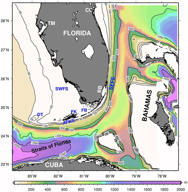
The South Florida (SoFLA) model domain and bathymetry (contours in m). It covers the Southwest Florida Shelf (SFWFS), the Southeast Florida Shelf (SEFS), the Atlantic Florida Keys Shelf (AFKS) and the Straits of Florida, extending from Cuba to Central Florida.
(TM: Tampa, CC: Cape Canaveral) and over the Bahamas and including shallow environments (FB: Florida Bay, BB: Biscayne Bay) and Marine Protected Areas (FK: Florida Keys National Marine Sanctuary, DT: Dry Tortugas Ecological Reserve).
RESOLUTION:
1/25 degree (~3.5 km), 26 vertical levels (sigma/z-coordinate in the upper model layers and near the shelf and isopycnic coordinate in deep waters).
NESTED: Yes
OUTER MODELS:
GoM-HYCOM, ATL-HYCOM, GLB-HYCOM
DATA ASSIMILATION:
Outer models only
FORCING:
Navy Operational Global Atmospheric Prediction System NOGAPS (1 degree) Coupled Ocean / Atmosphere Mesoscale Prediction System COAMPS (27 km)
APPLICATIONS: (sub-pages)
• Shelf Circulation
• Model evaluation
• Salinity Changes in Florida Bay
• Eddy Passages
• Florida Current Transport
CONTACT:
Villy Kourafalou— vkourafalou@rsmas.miami.edu