DESCRIPTION:
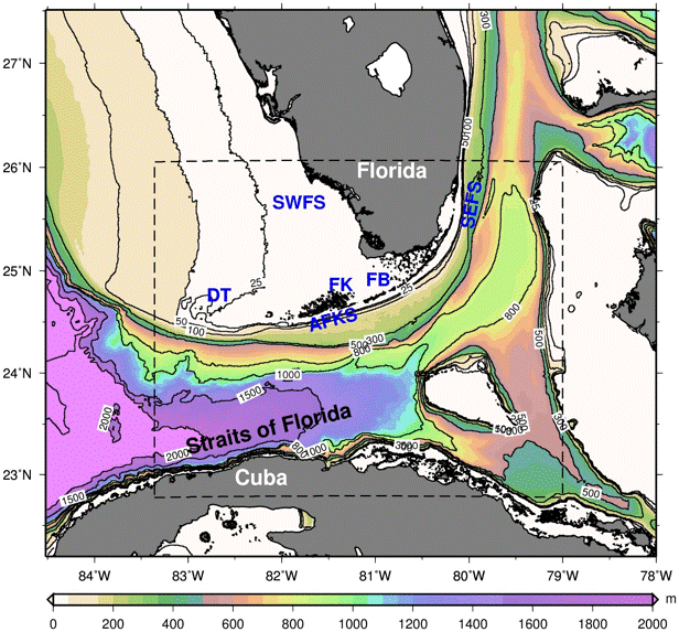
The current Florida Straits, South Florida and Keys (FKeyS) model domain and bathymetry (contours in m). It covers the Southwest Florida Shelf (SWFS), the Southeast Florida Shelf (SEFS), the Atlantic Florida Keys Shelf (AFKS) and the Straits of Florida, extending from Cuba to the Florida Keys and from the Bahamas to Biscayne Bay. (Dashed line Insert: previous FKEYS model domain, covering simulations from 2004 to 2012).
FB: Florida Bay, BB: Biscayne Bay and Marine Protected Areas, FK: Florida Keys National Marine Sanctuary, and DT: Dry Tortugas Ecological Reserve.
RESOLUTION:
1/100 degree (~900 m), 26 vertical levels (sigma/z-coordinate in the upper model layers and near the shelf and isopycnic coordinate in deep waters).
NESTED:Yes
OUTER MODELS:
South Florida (SoFLA-HYCOM)
Gulf of Mexico (GoM-HYCOM)
DATA ASSIMILATION:
No Data Assimilation
FORCING:
Hindcast:
(1) Coupled Ocean / Atmosphere Mesoscale Prediction System COAMPS (27 km): till April 2014
(2) NAVy Global Environmental Model (NAVGEM, 0.5o): from January 2013
(3) NAVy Global Environmental Model (NAVGEM, 0.281o): from January 2016
Forecast:
NCEP Global Forecast System (GFS, 0.5c). Starting August 1, 2015, use of GFS 0.25c has been implemented. It forecasts out to 180 hours.
APPLICATIONS:
• Eddies in the Straits of Florida
• Tortugas Eddy
• High Resolution Currents
• Sea Level Changes Due to Hurricanes
• Fish Recruitment in the Florida Keys
• Animations
• NEAR REAL TIME FORECASTS: Sea Surface Height and Surface Currents
• NEAR REAL TIME FORECASTS: Sea Surface Temperature
• NEAR REAL TIME FORECAST: Temperature at 50m
• NEAR REAL TIME FORECASTS: Surface currents (day 0 - day 3)
• NEAR REAL TIME FORECASTS: Surface currents (day 4 - day 7)
CONTACT:
Villy Kourafalou— vkourafalou@rsmas.miami.edu
HeeSook Kang— hkang@rsmas.miami.edu